Panther Island - 2006 Vision
The City of Fort Worth’s Comprehensive Plan calls for sustainable growth in all areas in close proximity to downtown Fort Worth. The district due north of downtown, Panther Island, has been rezoned by the City of Fort Worth to provide a mixed-used district of greater density. The district is impacted by the U.S. Army Corps of Engineers flood control project; however, no federal money is being used to accomplish the City’s sustainable growth goals for the district.
Phase 1 development in the interior of Panther Island is happening NOW. The development of Phase 1 can happen with or without the bypass channel and associated infrastructure being built. Click below for a general overview of project components.


MIXED-USE DEVELOPMENT
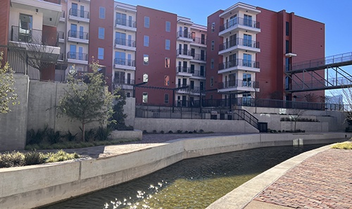
The award winning Panther Island Development Standards and Guidelines were adopted by the City of Fort Worth in 2006 to promote a high-density, mixed-use, urban waterfront district just north of downtown. The redevelopment of this area will increase Fort Worth’s tax base by bringing interest and investment back to the central city. An envisioned 10,000 housing units and three million square feet of commercial, retail, and educational space will make it possible for residents to live, work, shop, play and learn near the river. These improvements will make the now aging industrial area more pedestrian friendly, connect it to the Trinity River, and provide connectivity between several existing districts that have been historically fragmented. Development projects within the district must conform to minimum density requirements and principles which ensure quality, sustainable, pedestrian oriented development. Private development within this district generates income for a Tax Increment Financing District (TRV TIF #9) which provides the local matching dollars needed for infrastructure outlined in the Panther Island/Central City Infrastructure project. TRV TIF #9 is a self-funding mechanism, meaning that the taxes generated from private development occurring on Panther Island pay for the local costs of the Panther Island / Central City Project, not taxpayer’s citywide.
Click below for more information:
Panther Island Form Based Zoning District City of Fort Worth Urban Design District Administrative Process Panther Island (formerly called Trinity Uptown) Urban Design Plan Panther Island Canal Design Guidelines-
2015“Next Big Idea” Impact AwardsUrban Land Institute (ULI) of North Texas
-
2009Community AwardAmerican Institute of Architects (AIA) Fort Worth Chapter
-
2007CLIDE Award for Public Policy and PlanningNorth Central Texas Council of Governments
-
2006Current Projects AwardMidwest Section of the Texas Chapter of the American Planning Association
-
2005Citation of HonorTexas Society of Architects
-
2005Merit Award for Landscape Analysis and PlanningBoston Society of Landscape Architects
-
2005Top Honor ProjectThe Waterfront Center Excellence on the Waterfront
-
2003CLIDE Award for Public Policy and PlanningNorth Central Texas Council of Governments
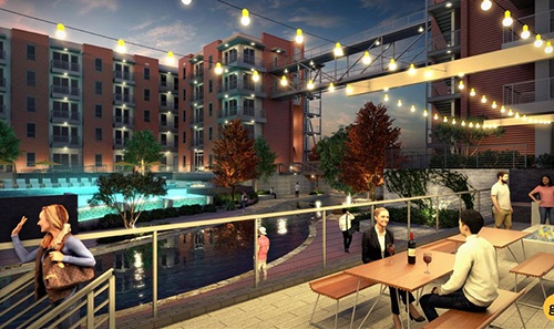
PARK SYSTEM
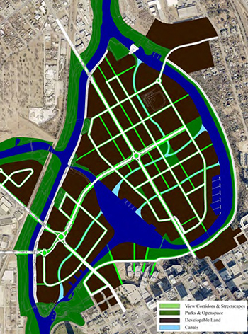
A fully integrated park system is incorporated into the Panther Island Urban Design Plan connecting lakes, canals and marinas through a network of trails. Seven different parks with distinct characteristics are carefully spread throughout the district. Pocket parks, plazas, festival and play areas will provide special places for the public to gather along the new waterfront edge. In addition, view corridors which are public spaces planned in between buildings will offer a unique opportunity for green space throughout the district connecting the park system.
MODERN ROUNDABOUTS
During the City of Fort Worth’s bridge design process for the Panther Island bridges, an independent peer review was performed to review design, functionality and potential cost savings associated with the bridges and adjacent intersections. A result of this review was a recommendation for the use of (3) modern roundabouts to more efficiently move traffic through Panther Island. Their studies showed that the roundabout provides safer roads by cutting average speed and delay time while handling more traffic with less right of way. Utilizing roundabouts allowed the bridges to be narrowed from six lanes to four lanes which resulted in cost savings. Studies also show that roundabouts create a positive environment for vertical development.
Located in the center of the White Settlement and Henderson Street roundabout is an art piece coined “Wind Roundabout.” This kinetic sculpture built by artist Ned Kahn, was commissioned by the City of Fort Worth through the Fort Worth Public Arts program as part of the Panther Island Bridge project. Thousands of small anodized aluminum hinge plates hang from tension cables on a 30 foot tall by 30 foot diameter stainless steel structure. It moves with the ever changing direction and force of wind in Fort Worth. “Wind Roundabout” was constructed and dedicated in 2015
Construction of the White Settlement & Henderson St. Roundabout was completed in 2015.
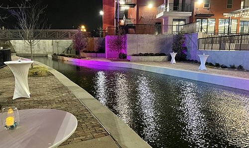
RIVERWALK
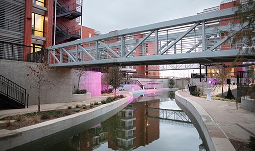
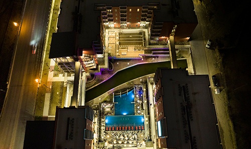
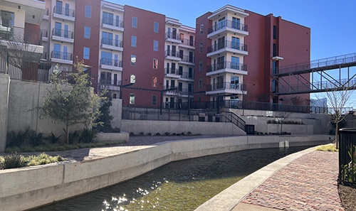
A major growth related need for the island are infrastructure improvements to the stormwater drainage system to serve the area. Understanding this system challenge, the working committee, along with city staff and their stormwater consultants, took a step back to see if there was a way to achieve an affordable fully built out neighborhood for Panther Island that would both manage stormwater efficiently and increase the quality of the pedestrian experience. The committee and city staff discovered the best way to achieve this was to create a system of internal canals on Panther Island that double as great pedestrian elements and serve as the main lines for stormwater management.
The stormwater canal system will provide needed flood protection, containing up to a 100-year flood event for the island. In addition to serving as an attractive solution for the stormwater needs for the area, the city’s ability to utilize the canals provides the City of Fort Worth a solution at roughly half the cost of the City of Fort Worth’s traditional storm water drain and gutter system.
A fully built out system of stormwater canals will address stormwater needs for Panther Island while also achieving the City of Fort Worth’s density and quality of life goals for the area. The canals will provide a beautiful new backdrop for the area that adds quality of life right along the water’s edge.
Click below for more information on Panther Island canals
Panther Island Canal Design GuidelinesFIXED TRANSIT LINE
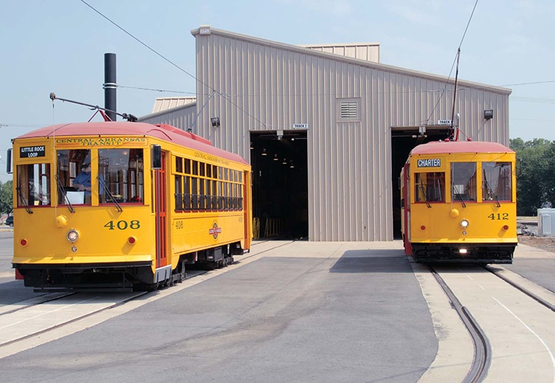
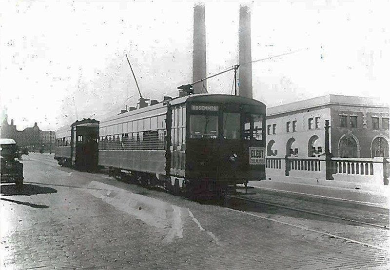
North Main Street, the North and South arterial that runs through the heart of Panther Island, was a main corridor where a fixed rail trolley once ran in Fort Worth. Since the trolleys departure, there are have been numerous studies and advisory committees that recommended the return of a fixed transit line to this corridor. Specific to Panther Island planning, the Panther Island (Formerly Trinity Uptown) Traffic Impact Study was conducted by the City of Fort Worth in 2006 to review transportation impacts as they related to the mixed-use development planned on Panther Island. The study recommended the implementation of a fixed rail transit circulator to link Panther Island to downtown and other nearby activity centers due to expected traffic congestion challenges that would arise if only a vehicuklar mode of travel existed. The study found that this would reduce projected vehicle delay by up to 12% within the Panther Island area, reduce per capita motor vehicle travel and reduce transportation costs. Fixed transit supports a successful mixed-use neighborhood by connecting Panther Island residents to the Downtown job center, relieving the transportation network, and promoting higher land use by minimizing the need for parking. Average density increase from 30% to 90% of zoned capacity is expected along mixed-use corridors.
Multiple studies have been performed by the City of Fort Worth in conjunction with local stakeholders related to city-wide transit needs that have recommended fixed rail transit on Panther Island.
Panther Island - 2006 Vision
The City of Fort Worth’s Comprehensive Plan calls for sustainable growth in all areas in close proximity to downtown Fort Worth. The district due north of downtown, Panther Island, has been rezoned by the City of Fort Worth to provide a mixed-used district of greater density. The district is impacted by the U.S. Army Corps of Engineers flood control project; however, no federal money is being used to accomplish the City’s sustainable growth goals for the district.
Additional development of Panther Island can occur once USACE has completed the bypass channel and associated infrastructure. Upon completion of the flood infrastructure and decommission of the existing levee system it will open additional land for private development. Click below for a general overview of project components.


MIXED-USE DEVELOPMENT
The award winning Panther Island Development Standards and Guidelines were adopted by the City of Fort Worth in 2006 to promote a high-density, mixed-use, urban waterfront district just north of downtown. The redevelopment of this area will increase Fort Worth’s tax base by bringing interest and investment back to the central city. An envisioned 10,000 housing units and three million square feet of commercial, retail, and educational space will make it possible for residents to live, work, shop, play and learn near the river. These improvements will make the now aging industrial area more pedestrian friendly, connect it to the Trinity River, and provide connectivity between several existing districts that have been historically fragmented. Development projects within the district must conform to minimum density requirements and principles which ensure quality, sustainable, pedestrian oriented development. Private development within this district generates income for a Tax Increment Financing District (TRV TIF #9) which provides the local matching dollars needed for infrastructure outlined in the Panther Island/Central City Infrastructure project. TRV TIF #9 is a self-funding mechanism, meaning that the taxes generated from private development occurring on Panther Island pay for the local costs of the Panther Island / Central City Project, not taxpayer’s citywide.
Click below for more information:
Panther Island Form Based Zoning District City of Fort Worth Urban Design District Administrative Process Panther Island (formerly called Trinity Uptown) Urban Design Plan Panther Island Canal Design Guidelines-
2015“Next Big Idea” Impact AwardsUrban Land Institute (ULI) of North Texas
-
2009Community AwardAmerican Institute of Architects (AIA) Fort Worth Chapter
-
2007CLIDE Award for Public Policy and PlanningNorth Central Texas Council of Governments
-
2006Current Projects AwardMidwest Section of the Texas Chapter of the American Planning Association
-
2005Citation of HonorTexas Society of Architects
-
2005Merit Award for Landscape Analysis and PlanningBoston Society of Landscape Architects
-
2005Top Honor ProjectThe Waterfront Center Excellence on the Waterfront
-
2003CLIDE Award for Public Policy and PlanningNorth Central Texas Council of Governments
PARK SYSTEM
A fully integrated park system is incorporated into the Panther Island Urban Design Plan connecting lakes, canals and marinas through a network of trails. Seven different parks with distinct characteristics are carefully spread throughout the district. Pocket parks, plazas, festival and play areas will provide special places for the public to gather along the new waterfront edge. In addition, view corridors which are public spaces planned in between buildings will offer a unique opportunity for green space throughout the district connecting the park system.
MODERN ROUNDABOUTS
During the City of Fort Worth’s bridge design process for the Panther Island bridges, an independent peer review was performed to review design, functionality and potential cost savings associated with the bridges and adjacent intersections. A result of this review was a recommendation for the use of (3) modern roundabouts to more efficiently move traffic through Panther Island. Their studies showed that the roundabout provides safer roads by cutting average speed and delay time while handling more traffic with less right of way. Utilizing roundabouts allowed the bridges to be narrowed from six lanes to four lanes which resulted in cost savings. Studies also show that roundabouts create a positive environment for vertical development.
Located in the center of the White Settlement and Henderson Street roundabout is an art piece coined “Wind Roundabout.” This kinetic sculpture built by artist Ned Kahn, was commissioned by the City of Fort Worth through the Fort Worth Public Arts program as part of the Panther Island Bridge project. Thousands of small anodized aluminum hinge plates hang from tension cables on a 30 foot tall by 30 foot diameter stainless steel structure. It moves with the ever changing direction and force of wind in Fort Worth. “Wind Roundabout” was constructed and dedicated in 2015
Construction of the White Settlement & Henderson St. Roundabout was completed in 2015.
RIVERWALK
A major growth related need for the island are infrastructure improvements to the stormwater drainage system to serve the area. Understanding this system challenge, the working committee, along with city staff and their stormwater consultants, took a step back to see if there was a way to achieve an affordable fully built out neighborhood for Panther Island that would both manage stormwater efficiently and increase the quality of the pedestrian experience. The committee and city staff discovered the best way to achieve this was to create a system of internal canals on Panther Island that double as great pedestrian elements and serve as the main lines for stormwater management.
The stormwater canal system will provide needed flood protection, containing up to a 100-year flood event for the island. In addition to serving as an attractive solution for the stormwater needs for the area, the city’s ability to utilize the canals provides the City of Fort Worth a solution at roughly half the cost of the City of Fort Worth’s traditional storm water drain and gutter system.
A fully built out system of stormwater canals will address stormwater needs for Panther Island while also achieving the City of Fort Worth’s density and quality of life goals for the area. The canals will provide a beautiful new backdrop for the area that adds quality of life right along the water’s edge.
Click below for more information on Panther Island canals
Panther Island Canal Design GuidelinesFIXED TRANSIT LINE
North Main Street, the North and South arterial that runs through the heart of Panther Island, was a main corridor where a fixed rail trolley once ran in Fort Worth. Since the trolleys departure, there are have been numerous studies and advisory committees that recommended the return of a fixed transit line to this corridor. Specific to Panther Island planning, the Panther Island (Formerly Trinity Uptown) Traffic Impact Study was conducted by the City of Fort Worth in 2006 to review transportation impacts as they related to the mixed-use development planned on Panther Island. The study recommended the implementation of a fixed rail transit circulator to link Panther Island to downtown and other nearby activity centers due to expected traffic congestion challenges that would arise if only a vehicuklar mode of travel existed. The study found that this would reduce projected vehicle delay by up to 12% within the Panther Island area, reduce per capita motor vehicle travel and reduce transportation costs. Fixed transit supports a successful mixed-use neighborhood by connecting Panther Island residents to the Downtown job center, relieving the transportation network, and promoting higher land use by minimizing the need for parking. Average density increase from 30% to 90% of zoned capacity is expected along mixed-use corridors.
Multiple studies have been performed by the City of Fort Worth in conjunction with local stakeholders related to city-wide transit needs that have recommended fixed rail transit on Panther Island.
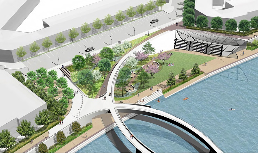
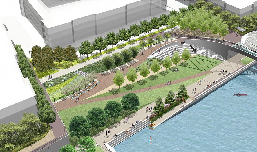
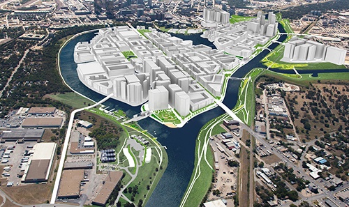
THE TRINITY RIVER PROMENADE
The bypass channel consists of the main low flow channel and the hard and soft edges. The soft edge consists of an earthen levee and overbank area which includes access ramps and trails for public use. The hard edge, otherwise known as the Trinity River Promenade, is primarily comprised of a series of retaining walls and walkways which include ramps and stairways meeting recreational, maintenance and access criteria for the project.
Made up of a series of unique urban parks all connected by a network of trails and new pedestrian bridges, the Promenade is designed to improve connectivity along the river. The Trinity River promenade will feature kayak launch pads, kayak / watercraft storage, riverbanks lined with shade trees, 12 ft.-wide waterside paths, water taxi landings, and more.
TOWN LAKE & MARINA
The 33-acre town lake expansion on Panther Island will allow for pedestrian powered water activity as well as a marina for boat parking.
HOUSEBOAT DISTRICT
The levees coming down gives you the ability to not just live next to the water but on the water. The houseboat district brings the urban neighborhood of Panther Island to the Trinity River.
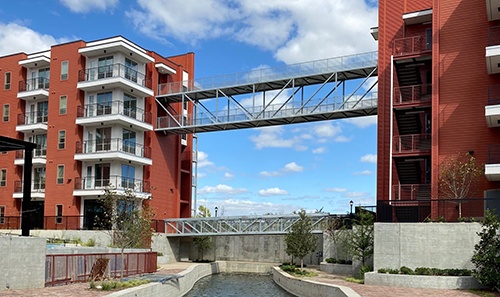
SIGNATURE PEDESTRIAN BRIDGES
To ensure continuous pedestrian access throughout Panther Island a series of pedestrian bridges will stretch the bypass channel allowing the trails on the island connect to 72 mile system throughout the city.